More black residents — both as owners and renters of housing units — constitute a major change in the Skinker-DeBaliviere area during the 1960s, census returns made public recently indicate.
The figures are census tract data supplied to the St. Louis City Plan Commission by the United States Census Bureau based on its decennial count of the population taken April 1, 1970.
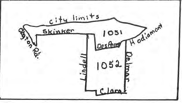
Census tract areas in St. Louis’s west end don’t correspond precisely to boundaries of the Skinker-DeBaliviere Community Council (see map).
But the areas for which figures are available are close enough to provide an insight into population trends in the Skinker-DeBaliviere area.
Total population in the two tracts that take in the Skinker-DeBaliviere area rose slightly between 1960 and 1970 — from 10,707 to 11,269.
But the big difference in the composition of our community is the number of blacks. Only 55 blacks lived in the two tracts in 1960, less than 1 per cent. By 1970 the number rose to 6208, or 55 per cent.
Leonard Hafertefe, a City Plan Commission staff member who aided The Paper in compiling the figures, noted that the black population in Skinker-DeBaliviere is actually higher than the 55 per cent figure because one of the census tracts extends to a primarily white area west of Skinker Boulevard.
In tract 1052, for example, which extends basically between Delmar, Clara, Lindell and Des Peres, total population rose from 6247 to 6731 between 1960 and 1970.
Racial composition in tract 1052 shifted radically in those ten years. Whites outnumbered blacks by 6167 to 33 in 1960 (47 residents were of other races). By 1970 5211 blacks lived in the tract as compared to 1478 whites and 42 others.
Tract 1051, which generally included the area from Des Peres and Hodiamont west to the city limits and extending south to Clayton Road, does not show a trend of such rapid change.
Total population rose from 4460 to 4538 during the 10-year period. The number of whites declined from 4421 to 3465 and blacks rose correspondingly from 22 to 997.
Housing statistics made available from the 1970 census report show that housing vacancies shot upwards during the 1960s in the Skinker-DeBaliviere area but the ratio of owners to renters remained about the same.
The total number of housing units in the two tracts went up slightly during the decade — from 4555 to 4660. But vacancies rose from a total of 274 in 1960 to 767 in 1970.
Figures in 1960 showed 3254 renter-occupied units and 1027 owner-occupied units in the two West End areas. By 1970 there were 2894 owner-occupied units — another slight decrease.
Blacks and persons of other races made gains in housing ownership in the Skinker-DeBaliviere area during the decade. Non-whites owned only 9 of the 1027 owned units in 1960 but owned 398 of 999 owned units in 1970.
Non-white renters rose from 26 of 3254 units in 1960 to 1234 of 2894 in 1970.
Women outnumber men in the two West End tract areas, primarily because of a major edge in the over 60 age range. There are 6068 women in the area compared to 5202 men.
Age breakdowns in the 1970 figures show 1249 women over 60 years old and 628 men in the same age range. There are 1181 women and 966 men between 35 and 59; 1451 women and 1481 men between 20 and 34 and 504 women and 497 men between 15 and 19.
Children in the neighborhood number 582 girls and 579 boys in the 10-14 age range; 583 girls and 550 boys in the 5-9 range and 518 girls and 501 boys four years old or less — a total of 3,313 children.
No comparable age figures for 1960 were available.
Archive note about the printed figures
One sentence labels 2,894 units “owner-occupied”; later sentences refer to 999 owned units and 2,894 renter units. The original wording and figures are preserved. This newspaper account is not a reconciled statistical table. The article also explains that its census tracts do not exactly match the neighborhood boundaries.
Original illustration caption
Map of Census Tracts
Originally published in The Paper, October 1971.
Read this article in the original newspaper issue.
Original source: SD_Times1971_10.pdf, printed page 1.
