Historical April–May 2011 article. Dates, prices, services and contacts describe the source period; current availability has not been established.
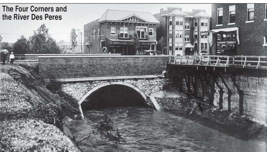
Editor’s Note: Thanks to Pat Kohn, who surprised Andy Cross with this incredible photograph of the flowing River Des Peres at the Kingsbury Bridge, with the art studio at 5947 Kingsbury in the background. Fortunately, we have an account of the time this bridge existed and how it transitioned to the street we know today.
The following description of the “gradual civilization” of the River Des Peres is from THE NEIGHBORHOOD, by Georgiana B. Stuart, Susan Tepas, and Kathy Harleman. Their 1973 work of research on the history of the neighborhood is also included in CELEBRATING SKINKER-DEBALIVIERE, published by the TIMES in 2008 and available at Missouri History Museum Shop or from THE TIMES.
It was on the banks of this river that Madame Papin’s land grant was laid out. Almost 100 years before the grant and 65 years before the founding of St. Louis, Jesuits from the Quebec set up a mission among the Kaskaskia Indians who were living at the mouth of a little stream flowing into the west bank of the Mississippi just east of the present Alabama Avenue.
This stream came to be known as River Des Peres or River of the Fathers.
The head of this stream is about 7 miles northwest of Forest Park.
It meanders southward through Survey 378 draining a total watershed of 70,000 acres.
The branch which enters the city near Delmar Ave. flows to the Skinker DeBaliviere area to Forest Park and then eastward to Kingshighway. Mr. Claude H. Wetmore (grandfather of Mrs. Betty Renard, one of our present neighbors [recently deceased]) has described as problematical river in his book OUT OF A FLEUR-DE-LIS: River Des Peres.
The first of these occurrences was the gradual “civilization” of the River Des Peres.
It was on the banks of this river that Madame Papin’s land grant was laid out almost 100 years before the grant and 65 years before the founding of St. Louis, Jesuits from the Quebec setup and mission among the Kaskaskia Indians who were living at the mouth of a little stream flowing into the west bank of the Mississippi just east of the present Alabama Avenue.
This stream came to be known as River Des Peres or River of the Fathers.
The head of this stream is about 7 miles northwest of Forest Park.
It meanders southward through Survey 378 draining a total watershed of 70,000 acres.
The branch which enters the city near Delmar Ave. flows to the Skinker DeBaliviere area to Forest Park and then eastward to Kingshighway.
It is a crooked, treacherous thing, this stream, and has borne that reputation since the time when St. Louisans pushed their homes and farms back from the Mississippi’s banks; and it has no title to the name of river except during a few months in each year, for in the summer it is a sike, the bed so dry as to offer a comfortable walk, dotted with many rocks which make famous resting places when one is tired.
But let a heavy rainfall and an angry, noisy mass tumbles through St. Louis County and the suburbs of St. Louis city, frothing in its effort to reach the “Father of Waters”; yet the desire satisfied, it refuses to mingle with the main channel and impresses its individuality by an extended yellow streak born of the clay which is carried along in its passage. Drive out any road that takes you beyond the limits and you will meet the River Des Peres in a half-dozen unexpected places, wriggling and squirming like a snake, doubling on itself frequently and at other times seemingly tied in a bow- knot. Let the rain continue a night and a day, and many of the acres of land that had appeared between the vexatious turns are overflowed; a weak steady downpour in the original crooked River becomes a broad wave, moving over wheatfields and rail-road tracks and reaching out hungrily for the little houses of truck gardeners.
It was the urbanization of the Skinker DeBaliviere area which finally led to the concrete encasement of this “individualistic” stream under the street which bears the river’s name.
The first steps to control a river were taken as more and more construction went on in our neighborhood.
In 1914 the City Planning Commission reported that extensive building and street paving in the River Des Peres water shed had caused a great greatly increased runoff of storm water during any rainfall “so that the channel of the stream is not sufficient to carry the volume of waterway and serious flooding occurs.” The storm water problem increased and to it was added a sewage problem.
When the Rosedale Skinker section was developed, a small sewer was built along the bottom of the river which carried not only the sewage of this section, but that of the whole area drained from the river by the city limits to Union Avenue and Forest Park. “The growth of this part of the city has been so great, however, that the increased flow of sewage generally over-taxes the intercepting sewer so that even a small rainfall or even a street sprinkling causes a considerable amount of sewage to overflow into the river channel.” Although the river was a nuisance to most adults because of the flooding in stench, most of the time it was an exciting play area for the neighborhood children. Judge Daniel B. Tammany, who grew up and still resides [in 1973] in the 6100 block of McPherson Avenue, remembers the river as it was when he was a child.
The river banks were “as wide as a street and about 40 or 50 feet deep.” The water, however, was only “as wide as a table” except during the spring rains.
There were bridges at Waterman, Kingsbury and Delmar for cars and a footbridge at Pershing. Where there were no bridges, wooden barricades ran along the banks.
The barricades didn’t keep the children from climbing up and down the river banks. Judge Tammany and his friends used to dig caves in the side of the banks and roast potatoes there over open fires.
In March of 1930 work to encase section F. of River Des Peres began.
This section includes the portion of the river which runs through our neighborhood.
During this construction, part of Voges’ drugstore, located on the northeast [southeast?] corner of Kingsbury and Des Peres Avenue, collapsed as did some corner houses. Other corner houses were purposely demolished to prevent their untimely collapse.
The work was completed in 1931 and the river no longer served to divide the neighborhood. Our “individualistic” river has not been completely “civilized,” however, and still brings problems of leaking and settling to basements on corner lots along Des Peres Avenue and even minor street flooding as recently as 1970.
Original photograph caption
River Des Peres at Kingsbury Bridge, with 5947 Kingsbury art studio in background. Photograph supplied by Pat Kohn; original photographer not credited.
Originally published in The Times of Skinker-DeBaliviere, April–May 2011.
Read this article in the original newspaper issue.
Archival transcription note: Reprinted historical extract repeats its opening narrative; northeast [southeast?] uncertainty already printed. Preserve all original wording, including duplicated passage and source errors.
Original source: SD_Times2011_04.pdf, printed page(s) 5; PDF page(s) 5.

