Historical November 1990 report or notice. Original dates, prices and contacts describe the source period; current availability has not been established.
Carrying a folding wooden field camera, a tripod; a box of 4″ x 5″ film, a lens and another camera into areas accessible only by foot and traveling nearly 30,000 miles by car, John P. Wickersham. Ph.D., explored the Missouri River Basin. shooting thousands of photographs to document the longest river in North America.
From its source at Hell Roaring Spring in southwestern Montana to its mouth 2700 miles later at its confluence with the Mississippi at St. Louis, the camera-toting professor has captured images of the rolling river.
His odyssey took him to 30 or 40 of the Missouri’s 90 tributaries, to lakes. reservoirs, ponds, dams, creeks, springs and towns in ten states and two Canadian provinces.
The Missouri River Portfolio, a portrait of one of the great waterways of the world. will be exhibited at the History Museum in the Jefferson Memorial Building in Forest Park from November 16 through March 15, 1991.
From his extensive collection of images. Wickersham has selected and printed 100 monochrome 9½ x 11 photographs for the show.
The exhibition will be open during museum’s hours, 9:30 a.m. to 4:45 p.m., Tuesday through Sunday, and there is no admission charge.
The photographer will introduce the exhibition with a slide-illustrated lecture on Friday, November 16 at 7:30 p.m.
A professor of philosophy at Maryville College for 28 years, Wickersham has studied photography, as an avocation, since high school.
In 1981 he created “A Chesterfield Album,” in which he showed the transformation of a farming community into a bustling suburb.
“That show was extremely focused and local in interest,” Wickersham says, “but because part of Chesterfield is bordered by the Missouri River, it led me to this project. I began photographing the Missouri in the state, but saw the importance of doing the whole river, then the whole basin and the tributaries. Looking at the geography, I realized it was a daunting project—I have yet to find that anyone else had completed a photographic study of the Missouri River Basin.”
The basin ranges in altitude from Colorado’s 14,285 foot Mt. Lincoln to the Ozark Plateau and the Great Plains.
It ranges in latitude from Saskatchewan’s Frenchman River—its northernmost tributary—to Missouri’s Boiling Springs in the Big Piney River—its southernmost tributary.
Along these rivers occurred most of the storied events which comprise the westward movement of the American People in the 19th century:’ he says. “The Missouri was the great road into the Indian lands. the pathway of Lewis and Clark, the waterway for the mountain steamboats, the highway of furs, gold, and later. shame and blood!’ “So the photographs have a two-fold interest—a documentary survey of the Basin waters, and an expressive response to that landscape.
In striving to create an aesthetic series, I was presented with many choices.
I have selected images that seem to me to represent the spirit and appearance of the Missouri Basin, from all seasons of the year and from varied geographic points of view:’ The photographs will be accompanied by brief narratives explaining the landscape. Detailed maps will also help the viewer place the images in the context of the entire Missouri River Basin.
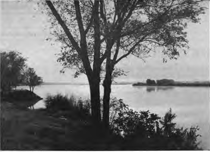
Original photograph caption
The Missouri River, Yankton, South Dakota, from the Missouri River Portfolio, photographs by John Wickersham. On exhibit at the History Museum in the Jefferson Memorial Building in Forest Park, November 16 to March 15, 1991. The Times of Skinker-DeBaliviere, November 1990, page 2.
Originally published in The Times of Skinker-DeBaliviere, November 1990.
Read this article in the original newspaper issue.
Original source: SD_Times1990_11.pdf, printed page(s) 2; PDF page(s) 2.
