Originally a portion of the 18th century Spanish land grant to Marie Louise Chouteau Papin, sister of St. Louis cofounder Auguste Chouteau, much of the Skinker-DeBaliviere-Catlin Tract-Parkview Historic District remained within extended Chouteau-Papin family until late in the nineteenth century. North of Delmar, the land belonged to James Clemens, Jr. who had married the daughter of John Mullanphy, St. Louis’s first millionaire. South of Forest Park Parkway, the land now called the Catlin Tract was owned by Robert Forsyth, a portion of the 800 acres his father had bought from Jean Marie Papin in the 1820s. The section from Kingsbury north to Delmar belonged to Larkin Deaver, who had married Frances Papin. The section from Kingsbury south to Forest Park Parkway was owned by Captain James W. Kingsbury, West Point Class of 1824, who married Julia Cabanne in 1830. Their two daughters, Sarah Mary Virginia and Adele Louise, subdivided the “Kingsbury Farm” in 1873 and are responsible for some of the street names in the area today: Kingsbury, DeGiverville, for Mary Virginia’s husband, Count de Giverville; Waterman, for Adele’s husband, Alfred Waterman; and DeBaliviere, named for the mother superior of the convent school in Paris which both sisters attended. Skinker Road was logically the road to Thomas Skinker’s home.
This area had originally been requested by Madame Papin for a farm and, because of its topographical nature, faced constant threat of inundation by a snakelike River Des Peres which yearly rose beyond its banks to flood the low-lying area. The river’s threat caused the land to remain an area of truck-farms until the turn of the century. Development of land to the south and east of the Kingsbury Farm as a huge city park, along with rapid expansion of residential sites west of Grand Avenue led to the dedication of Forest Park and the establishment of the boundaries of the City of St. Louis just west of the park in the same year, 1876. By 1895, westward expansion had continued so vigorously that Robert S. Brookings chose land just west of Forest Park as the site of the new campus of Washington University. North of Delmar, to the east of the Wabash Railroad tracks, was the highly desireable residential area known as the Cabanne District. Immediately east of DeBaliviere, several fine private residential subdivisions were built in the 1890s, continuing the direction of quality residential development along the City’s central corridor. New street car facilities along Delmar and the current Forest Park Parkway linked the area to the rest of the City. Obviously, with development to the north and east, Forest Park to the south and Washington University continuing west from there, another look was taken at the farmland so long dominated by the unruly River Des Peres!
First the prospect, then the reality of the Louisiana Purchase Exposition being sited in the western, undeveloped portion of Forest Park precipitated action in the area in the spring of 1901. A sudden rash of land purchases occurred in this rural area by one Courtland B. Van Sickler, a resident of the Cabanne District and listed in the city directory as a clerk as the Carletron Dry Goods Company downtown. By November, 1901, Parkview Realty and Improvement Company had been formed with Van Sickler the majority stockholder in this, the third company to announce major plans for the land in six months. The capital stock of Parkview Realty totaled $5,500,000, an enormous sum for the time. This development company had some major plans later stated thus: “improving the immense tract as one property, which plan would so develop that the building and treatment of each part will add to the value and betterment of the remainder.” They hired John Scott, a highly regarded railroad builder, to grade the land and tame the River Des Peres. Parkview Realty and Improvement Company owned everything from the northern boundary of Forest Park to Delmar Boulevard, and from DeBaliviere Avenue west to Melville Avenue in St. Louis County, excluding only Washington University land at the southwest corner of the tract. The grading contract was let in February, 1902, and work was not completed until December, 1903, more than a year later than originally planned. This grading cost over three-quarters of a million dollars and resulted in a long court suit about the proper fee for Scott which dragged on until it reached the Missouri Supreme Court in 1914.
The development plan for all of
Parkview Realty’s land was expressed in this manner in a promotional brochure about 1903: to improve the area on the northern edge of the park, the Catlin Tract, for “lease to the “World’s Fair, Railroads and Hotels”; lease the land between DeBaliviere and Skinker north of the Catlin Tract for storage or temporary hotels and cottages and restaurants during the Fair; and to have a private company of “friends and insiders” develop the area west of Skinker as a private subdivision of “artistic homes” in “artistic surroundings”. The long, narrow strip bordering Forest Park, the Catlin Tract, had been the first development work done by Parkview Realty, “graded and improved with streets, gutters, curbs, sidewalks, sewers, gas, trees and shrubs, all at an expense of about $350,000.” As planned, the Louisiana Purchase Exposition Company leased this property and it was used as the World’s Fair amusement center, “The Pike”.
General economic conditions (such as the nationwide Panics of 1903 and 1907) and, no doubt, the continuing suit of John Scott, prevented Parkview Realty and Improvement Company from personally carrying out the rest of their plans. But after the Fair, the company’s directors and friends formed other development companies and proceeded to continue in the original vein.
The first new development undertaken was Parkview subdivision. In November, 1905, the Beredith Realty Company, a new organization created by Parkview Realty specifically to develop that area, filed plats and a Trust Indenture in both the City of St. Louis and St. Louis County (whose boundary the property straddled), establishing the private subdivision of Parkview. Henry Stewart Caulfield (later to serve as governor of Missouri) was a principal figure in Parkview’s founding and development, a role which he continued as resident and Trustee for the rest of his life. Julius Pitzman, the designer of most of St. Louis’s private places, designed and surveyed the streets and property, as well as becoming a shareholder in Beredith Realty Company.
Although the distinction of Parkview is in its planning and overall appearance, and there was little innovation in the architecture of its houses, the wide variety of historical styles and multiplicity of historical details used by architects and builders of this period contribute greatly to the visual interest of the area.
Among the types and styles are the side-entry house, perhaps derived from the Italianate townhouses of the Central West End; the symmetrical center hall plan often Georgian in style; and the gabled-roofed, half-timbered, bracketed house of Medieval or Elizabethan origins. The three most elaborate and pretentious houses are on large lots in the center of the subdivision: 6251, 6303 and 6309 McPherson. Architect Otto J. Wilhelmi created two freely eclectic designs: 6251 McPherson, built for brewer C. Marquard Forster, of grey brick embellished with Classical and Baroque details of stone, terra cotta, and cast iron, and 6303 Mc Pherson, for Forster’s mother-in-law, Mrs. Schlosstein, of red brick which combines classical details with a Medieval round corner turret capped with a conical roof. At 6309 McPherson is a large Tudor country house designed for prosperous hardware merchant George Rubelmann by Ernst C. Janssen. More modest in scale and more correct in the interpretation of historical styles are several houses by Roth & Study (John Roth and Guy Study), the most significant being the gabled, half-timbered Tudor house at 6334 McPherson.
Several other well-known architects of the period are represented but, additionally there are a number of speculator-builder houses, most notably those of George Bergfeld who constructed 35 houses between 1910 and 1913, plus his own residence at 6352 McPherson, built in 1919.
Within a year or two from the beginning of construction activity in Parkview, streets were built and houses were going up east of Skinker. George Bergfeld was active here, too, especially in the 6100 block of Kingsbury. Other major builders were A.A. Fischer and Humphrey & Vickery. Building setback lines, including porch lines, were rigidly adhered to and the scale of the houses is remarkably consistent, but a variety of roof types (mansard, gabled, hipped), use of dormers and varied window treatment, free and sometimes creative use of architectural details such as columns and pediments and applied facade embellishments, plus skill in the crafts of brick, stone and terra cotta work, enrich the visual appeal of the houses. Apartment buildings, a booming housing form of the period, were often planned with projections, courtyards, bays and balconies for maximum exposure to light and fresh air.
East of Des Peres, with construction taking place generally between 1910 and 1920, houses were frequently two story and smaller in size, and elaborate use of decorative details gave way to a more modern and simple house type with wide, broad-roofed front porches related to the Bungalow style.
In contrast, along the edge of Forest Park, a private subdivision was platted for expensive, more elaborate homes. The design of the subdivision, which actually begins at Union Boulevard, called the Catlin Tract (after Daniel Catlin, tobacco manufacturer, later real estate holdings and banking), required lots to be at least 100′ wide along Lindell Boulevard and provided architectural opportunities for a fine view of the park from several rooms in each house. Houses therefore frequently took the form of spacious country houses of various styles: French Chateaux, Italian Villas, Spanish Haciendas, and English and German country houses. Several well-known St. Louis architectural firms are represented: Study and Farrar, 5783; Maritz and Young, 6145, Barnett, Haynes and Barnett, 6159; Maritz and Henderson, 5933 and 6127.
Three churches in the Historic District are neighborhood landmarks and focal points for much social activity. St. Roch’s Catholic Church was the first to hold services in the area, in 1911. Erection of a school (1912), rectory (1915) and finally a church (1922), designed by Lee and Rush in the Tudor Gothic style, shows the growth of the parish over a short 10 years. Grace Methodist Church was designed by Link, Rosenheim and Ittner and built on a site at Lindell Boulevard and Newstead Avenue in 1897. During the next 15 years, a great population movement westward convinced this Methodist congregation to move west and, having secured a site at Waterman and Skinker, they moved their church stone by stone, the top stones of the old church becoming the bottom stones of the new one. Grace Church was completed in 1914 and boasts one of the few Tiffany windows in St. Louis. Delmar Baptist Church was the last of the three currently-existing major churches to move into the neighborhood, but is the oldest of the three congregations. Moving many times after its founding in 1877, as the St. Louis population moved westward, this Baptist congregation several times fought for its very existence before buying from Grace Methodist the lot at Washington and Skinker in 1916. World War I rescheduled all building plans and the church, designed by William B. Ittner, was not completed until 1919.
GENERAL PLAN
In an era predating municipal zoning (introduced in University City in 1922; St. Louis in 1926), when residential property was often encroached upon and frequently destroyed by commc’l. & industrial development, the problem of control was a major concern to developers of new residential areas. A general plan for the entire Parkview Realty tract had been stated as early as 1903 and followed by subsequent developers.
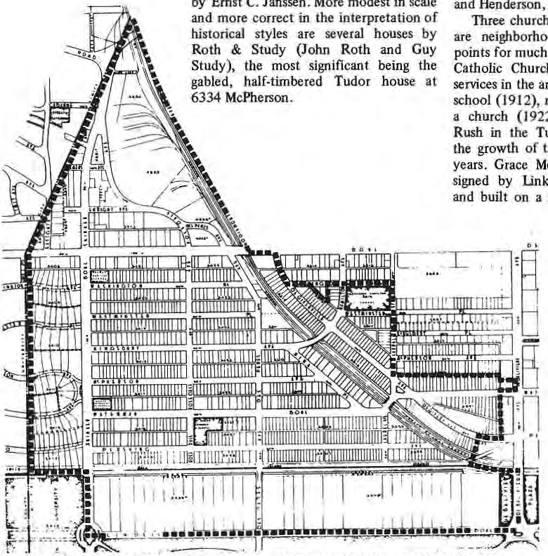
Parkview was the largest of St. Louis private places, comprising 271 lots on 70 acres, and it demonstrated Pitzman’s most complex street patterns. Five existing city streets enter Parkview from Skinker Boulevard, roughly in line with their eastern origins, but are turned toward each other in generally a doublehorseshoe-shaped configuration with only one western gated outlet at the center.
This design effectively created a pattern of inner circulation which gives the subdivision a sense of closeness and identity. In addition, the curved streets are visually attractive and at the time of their creation stood nearly alone in the prevailing grid patterns of most city streets. The only other significant examples are parks and cemeteries, and two residential subdivisions: Clifton Heights, established and surveyed in 1885 when Pitzman was the City Surveyor, and Compton Heights, designed by Pitzman around 1890. Curved streets were used in the design of a few early developments in the county but these, like Clifton Heights, were all on hilly terrain and were suburban rather than urban in character. Parkview’s strong ordering elements such as uniform setbacks, fairly closely spaced. three-story of generally similar scale and form and colonnades of regularly spaced street trees are decidedly urban qualities. Combined with the elements of grace due to the gently curving streets, they produce a residential area that is unique in St. Louis.
Parkview Realty’s General plan, having begun with Parkview Subdivision, which through its size expanded the St. Louis private street concept of control through deed restrictions, moved next to the street just east of Skinker. In this area, platted in 1907 as Washington Heights, the inner streets were reserved for relatively large single-family houses, and on the streets to the north and south, especially along the streetcar lines, were built two-family houses or apartment buildings. A few small shops served interior neighborhood needs at the Kingsbury and Pershing intersections with the River Des Peres bridges.
In Washington Heights First Addition, extending east from the River Des Peres, which was platted in 1909, the trend of the “protected core” continued. Waterman and DeGiverville Avenues formed an X-shaped core of single-family houses with smaller one and two-family homes, then apartment buildings radiating outward. The Washington Heights Second Addition (not included in the Historic District because of its present redevelopment status) became an apartment area serving as a buffer between the neighborhood’s inner core and the busy intersection of Delmar and DeBaliviere, where the United Railway Company’s carbarn, powerhouse and waiting room were located and which was destined soon to be bustling with traffic and commerce.
New commercial development grew rapidly along Delmar after World War I, becoming the site of a major streetcar line to the west. Most shops were small, however, and served only the surrounding neighborhoods.
Skinker, a wide major boulevard near the City’s western boundary, was the site of large handsome apartment buildings and churches as well as the homes on the corners of intersecting residential streets.
Along the southern edge of the district, the valuable strip of land facing Forest Park, running from Skinker to Union, was reserved for the most expensive residential development in the Parkview Realty tract, continuing the manner of development to the east.
The gradual realization by developers seeking to establish a stable residential section in a growing city that they must enlarge and coordinate their area of control seems to have reached its final solution within the Skinker-DeBaliviere-Catlin Tract-Parkview area. The result was a community of planned economic mixture built within the space of twenty years, the great majority of the construction having been completed within the first ten years. Never the home of the very wealthy, the area basically attracted owners of good, solid growing businesses and many upper and middle management. executives. Also included among the residents were doctors, lawyers, clergymen, architects, writers and, of course, faculty members from the local schools, colleges and universities, especially nearby Washington University. In addition, there were clerks, students, salesmen, city and state employees from all levels, and many others.
CONCLUSION
The survival of the area, now over 70 years old, with nearly all of its original physical and social structures intact, is a tribute to its planners. Most recently, however, as the neighborhood has begun to show its age, new efforts have been necessary for its preservation and social growth. Housing rehabilitation has been a major goal of owners old and new and of specific neighborhood organizations (the Skinker-DeBaliviere Community Council and its Residential Service), all of whom consider the quality and architectural interest of the houses and the planning integrity of the area to be important assets. Attention is now being turned toward commercial areas which have largely lost contact with much of the neighborhood due to the demise of the streetcar and the greater mobility of the automobile. Residents feel that, as in the past, many neighborhood commercial needs could be met within the area to the benefit of both residents and businessmen.
Following the logic and success of the original planners, current planning must continue to see the whole area as a coordinated entity within the City. The Skinker-DeBaliviere-Catlin Tract-Parkview Historic District includes a variety of residential areas plus adjacent commercial and industrial uses in the hope that the continued preservation and mutual support of all of these parts will strengthen the entire district and maintain for the City this example of an unique, fullyplanned neighborhood from St. Louis’s glorious days as fourth largest city in the United States.
Original photograph caption
Skinker-DeBaliviere–Catlin Tract–Parkview Historic District. Original map from The Paper, June 1977, page 5. Map artist not credited.
Originally published in The Paper, June 1977.
Read this article in the original newspaper issue.
Archival transcription note: Printed desireable, commc’l., and three-story of generally similar scale retained.
Original source: SD_Times1977_06.pdf, printed page(s) 5, 8; PDF page(s) 5, 8.
